Technologies

Providing geospatial and technological solutions across a broad range of sectors, including the built environment.

Projects

Implementation of the spatial integration framework and the revision of the current GIS based spatial equity tool

Implementing spatial integration framework and revising GIS-based spatial equity tool

Focus Project Management, together with GeoAfrika Technologies have been appointed to support KZN CoGTA with the implementation of the Spatial Integration Framework (SIF) and the revision of the current GIS based Spatial Equity Tool (SEPT). This includes the analysis, testing and the updating of the existing tool to align with
Tongaat Hulett Property GIS Support Service

Tongaat Hulett Property GIS Support Service

GeoAfrika Technologies has provided Tongaat Hulett Developments with continuous service since 2002. This support includes; provision of a full-time onsite GIS Technician, the provision of GIS resources as back-up to the onsite Technician and for supplementary work, the provision of a GIS Specialist to oversee the technical aspects of the
United Nations Population Fund - Adolescent and Health Service Mapping

United Nations Population Fund – Adolescent and Health Service Mapping

The UNFPA appointed GeoAfrika Technologies to map adolescent sexual and reproductive health, and HIV service delivery points and providers, and to provide a user-friendly GIS database and viewer that can be used to interrogate this data. The points were mapped in the 8 UNFPA supported priority district municipalities in the
Integrated Municipal Property Information Management System

Integrated Municipal Property Information Management System

The Integrated Municipal Property Information System is a Geographical Information Systems (GIS) web-based system that enables users to view and query municipal property-related information from multiple departments within a municipality from a single web portal. This system has been implemented at Ingwe and Kokstad Local Municipalities and all seven of
District Health Information System

District Health Information System

The District Health Information System provides an efficient and user friendly platform to support the monthly and quarterly reporting requirements of the KwaZulu-Natal Department of Health. Officials at hospitals, clinics and district and regional offices are able to set monthly and quarterly performance targets and to capture actual performance against
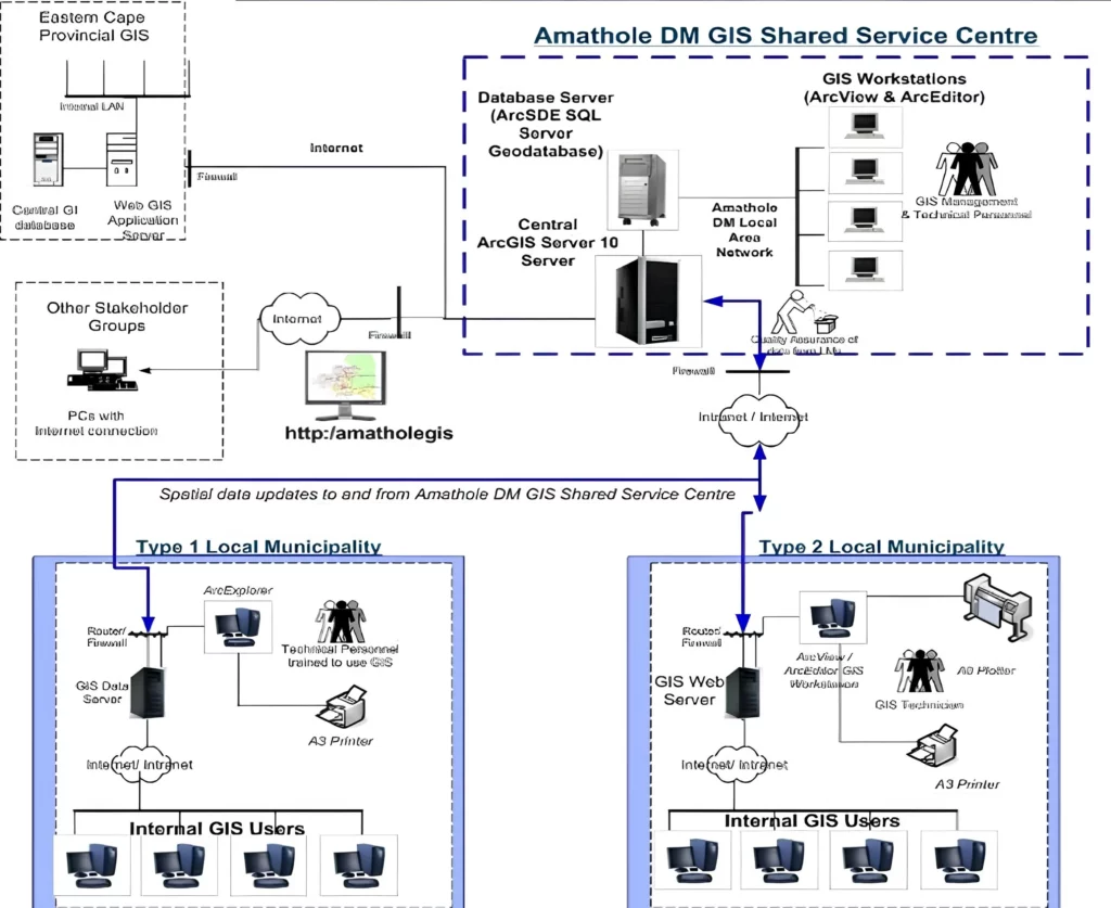
GeoAfrika developed a custom GIS web portal for Amathole District Municipality, providing secure access to integrated spatial and non-spatial datasets that support property management, planning, and informed municipal decision-making.

Amathole District Municipality GIS Web Portal

The Amathole District Municipality GIS web portal consists of a traditional information portal and a number of customised GIS-based views. The views include an Integrated Municipal Property Information System that allows users to view and query detailed municipal property information in association with a number of GIS datasets that have